
Page 17 - planning-committee-packet
P. 17
The site is comprised of mainly Elkton Sandy Loam, and Fallsington Sandy Loam which are classified as Hydrologic
Group C/D and B/D soils respectively per published USDA soil maps. Based on the presence of non-tidal wetlands, and
an existing submerged gravel wetland on-site, the soils are assumed to be undrained and are therefore assumed to be D
soils for the purposes of this analysis.
Proposed Project
The proposed project consists of constructing a 4-story hotel with an outdoor pool and patio area. The proposed project
will provide 69 parking spaces with 5 spaces being ADA compliant and has been designed to meet Town of Berlin design
standards. The site has existing water and sewer services stubbed at the southeast and northeast corners of the site
which connect to mains on Parcel 683, Lot A. Stormwater management compliance and landscaping will be provided
on-site as required by the Town of Berlin.
Stormwater Management
The primary drainage area on the subject parcel (EX-1) drains to an existing non-tidal wetland onsite (Study Point 1) that
drains north to Kitts Branch as shown on the drainage area maps.
The proposed project will utilize submerged gravel wetlands to capture runoff for both water quality treatment and
quantity management. Drainage conveyance on the site will be accomplished by sheet flow and a network of inlets,
trench drains, and storm drain pipes to direct runoff to the proposed submerged gravel wetlands.
Stormwater quality management computations and compliance are based on the overall proposed limits of disturbance
(LOD) area, land cover and curve numbers, soil types, other parameters as required. For the purposes of quantity
management, the site was analyzed to ensure that the 2 and 10-year storms are managed on-site, and the 100-year storm
can be safely conveyed. The remaining area on-site was not included in this analysis as there are no improvements
proposed in this area.
Stormwater Quantity Management
Study Point 1 was used to evaluate the effects on downstream/offsite drainage patterns based on the changes that will
occur as part of the proposed project development. The study point was analyzed for the 2-, 10-, and 100-year storm
events per the Delmarva Hydrograph, in both existing and proposed conditions. The proposed submerged gravel
wetlands will discharge through notched weirs and during larger storm events, will overflow through concrete overflow
weirs at non-erosive velocities.
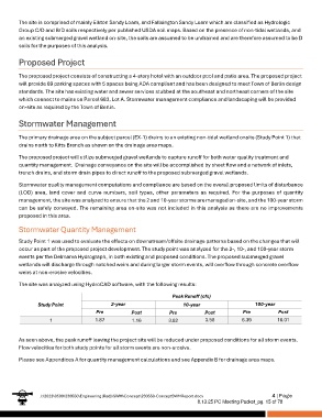
The site was analyzed using HydroCAD software, with the following results:
Peak Runoff (cfs)
Study Point 2-year 10-year 100-year
Pre Post Pre Post Pre Post
1 1.87 1.16 3.82 3.58 6.39 16.01
As seen above, the peak runoff leaving the project site will be reduced under proposed conditions for all storm events.
Flow velocities for both study points for all storm events are non-erosive.
Please see Appendices A for quantity management calculations and see Appendix B for drainage area maps.
J:\2023\0500\230550\Engineering (Red)\SWM\Concept\230550-ConceptSWMReport.docx 4 | Page
8.13.25 PC Meeting Packet_pg. 15 of 78